|
|
KING EDWARD VI CAMP HILL SCHOOL FOR BOYS
GEOGRAPHY DEPARTMENT CHESTER - 2000 |
|
HUMAN GEOGRAPHY
|
MODERN CBD
|
 |
Foregate.
This is the view looking eastwards from the city walls. Note that the
CBD has extended beyond the walls here unlike the other three gates.
Why is this? What changes in land use did you see as you walked along
the walls? How have the walls affected modern day land use?
|
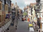 |
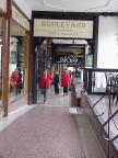
This
is Eastgate. This is the view westwards towards the Cross. Note it has
been pedestrianised. How can this photograph support our thesis that
relic land use has affected the land use distribution in the modern
CBD?
|
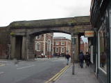 |
This
is Northgate. Note the abrupt change in land use inside and outside
the gate. Inside it is retail and outside a school. Accessibility for
the pedestrian is severely limited by the barrier of the walls. Retail
needs to be accessible to the pedestrian and therefore locates away
from the barrier of the walls.
|
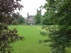 |
The
Cathedral which was built originally in the medieval period. It reflects
the wealth of Chester.The church remains outside of the pressures that
have changed old land uses. Note this is the corner of the walled town
that would have been kept open so that food could be grown during times
of siege.
|
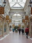 |
The
relic land use of retail at the Cross has remained. It has been adapted
to the development of a modern under cover shopping centre behind the
facade of the old buildings. The relic land use of defence, as manifest
in the walls, has constricted the modern day land use within the CBD.
|
 |
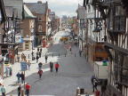
The
medieval ROWS of the market area of Chester. These are unique to Chester.
It is believed that traders built shops on top of the ruined Roman walls
to gain access to shoppers.
|
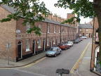 |
This
is industrial housing within metres of the busy retail core of the CBD.
This low grade land use can only remain because of the barrier to accessibility
brought about by the medieval walls.
|

|
|