|
|
KING EDWARD VI CAMP HILL SCHOOL FOR BOYS
GEOGRAPHY DEPARTMENT CHESTER - 2000 |
|
HUMAN GEOGRAPHY
|
MEDIEVAL
|
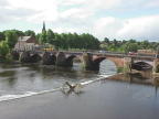 |
The
Medieval narrow bridge across the River Dee - called Handbridge. This
was the lowest bridging point of the river Dee until the new bridge
of 1839.
|
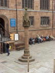 |
The
Cross - this marked the centre of the fortified walled medieval settlement
of Chester. It is around this central point that the market would have
grown. Note the medieval cross and church are both built from sandstone
hewn from the ridge on which Chester stands.
|
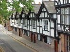 |
Medieval
Almshouses built to house the old and infirm. It would have been the
privilege of the pious to live here.
|
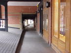 |
The
medieval ROWS of the market area of Chester. These are unique to Chester.
It is believed that traders built shops on top of the ruined Roman walls
to gain access to shoppers.
|
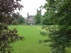 |
The
Cathedral which was built originally in the medieval period. It reflects
the wealth of Chester. In medieval towns one corner of the walled area
was usually left open as farmland to guard against starvation in times
of siege.
|
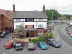 |
In
medieval times visitors to the town market had to leave the walled city
by nightfall. They rested outside the walls in Inns. This is an example
of FAUBERG development at Watergate.
|
|
|